

STANDALONE TRAIL MAP
TRAIL INFORMATION

Details
| Status: | Closed |
| Difficulty: | Intermediate |
| Uses: | Mt Biking & Hiking & Equestrian & Motorcycle & eBikes |
| Length: | 4.1 miles |
| Start: | 5,908' |
| End: | 6,986' |
| Min: | 5,908' |
| Max: | 7,465' |
| Gain: | 1,637' |
| Loss: | -568' |
| fly your trail in 3D | |
 |
Google Earth KML file
Download KML file above, open in Google Earth to see this trail in 3D! |
| don't get lost |
| GPX file (right click to download)
Download GPX file above, upload the track to your GPS or smartphone and you'll always know where you are!! |
Trailhead Forecast
Description / Access Information
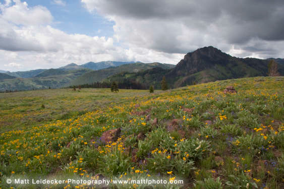
Cow Creek Trail #180: Very open and south facing at its low end; near the trailhead. Early springtime opportunity for out-and-backs. Early loop opens when short-cut trail opens over to Cow Creek Connector Trail.
A rocky trail most popular with people looking for a lesser used route. Route finding can be difficult at the high end of this trail. There, some game-trails break off, and the trail fades away where it crosses a creek and boggy meadow.
One of the most lightly used trails in the Greenhorn network. This stoney and demanding trail makes for a pleasant hike or horseback ride. It is a welcome challenge to strong mountain bikers looking for some areas of rocky technical terrain.
This trail climbs north from the trailhead through the open lands that are adjacent to the Forest Service fenced pasture. Right off the bat, this trail is full of embedded river rock. It's very technically challenging in that regard.
It's not long before the trail really starts to climb as it takes you toward the higher reaches of the Cow Creek drainage. The trail leads to the Cow Creek Shortcut Trail, which provides a more direct connection to the Cow Creek Connector Trail #153. If you forego the Short Cut Trail, and stay on the Cow Creek Trail #180, it too will lead you to the #153 trail; albeit a much longer way over to that side of the drainage. Also, if you use the higher reaches of the #180 Trail, some game-trails branch off from the main route, and the trail goes away in a boggy meadow near the top of the drainage. You may need to poke around a bit, and do some route finding to stay on trail.
*For more detailed descriptions, topo maps, and information on the history, geology, and wildflowers of the Wood River Valley pick up a copy of Exploring Sun Valley online or find it at one of several local shops.
The Greenhorn Gulch drainage, which includes Cow Creek, Lodgepole Gulch, Mahoney Gulch, Greenhorn Creek, and Imperial Gulch has the highest concentration of multi-use trails in the valley. Much of the northern half of the drainage was burned quite severely during the Castle Rock Fire in 2007, and a great deal more burned in the 2013 Beaver Creek Fire. The trails were reopened through the efforts of the Forest Service and its many community partners. In 2014 volunteers with the Wood River Bicycle Coalition, Idaho Mountain Dirt Riders Association, Boy Scouts of America and the work of the Ketchum Ranger District Trail Crew and the Northwest Youth Corp did a great deal of work to get the trails reopened in 2014.
The trails in Greenhorn pass through a wide variety of terrain from dense forest to open grass and flower-covered slopes, meandering ridgelines and, more recently, burned and limbless forests recovering from the fire. The interconnected nature of the Greenhorn trails allows for a wide variety of loops as all of the drainages are linked along the western divide.
For hikers, many of the loops are longer than they may want to travel in a single day. There are several shorter options between the Cow Creek and Mahoney Gulch trails. Out-and-back hikes are also a great option on both the Greenhorn and Imperial Gulch trails.
The motorcycle community was instrumental in the funding, improvement, and connection of the Greenhorn, Deer Creek, and Warm Springs Creek trail networks. Funds from the Idaho Department of Parks and Recreation paid for a lot of motorized specific trail development in the late ‘70s and early ‘80s. As a result, all of the trails in Greenhorn Gulch are multi-use and open to motorcycles. Please respect ALL user groups you encounter. Everyone has a right to enjoy this wonderful network of trails.
Directions:
From Ketchum, head south on Highway 75, or the paved Wood River Trail, for 5.5 miles to the Greenhorn/East Fork Road at the stoplight. Head right/west for 3.7 miles to the end of the Greenhorn Road at the FS Greenhorn Trailhead.
From Hailey, head north on the highway or the path. Its 5.5 miles to the Greenhorn/East Fork Road at the stoplight. Head left/west for 3.7 miles to the end of the Greenhorn Road at the FS Greenhorn Trailhead.
The Cowhorn Tr. #180 departs the trailhead from the north side of the parking area; near the equestrian parking loop and toilet.
*For more detailed descriptions, topo maps, and information on the history, geology, and wildflowers of the Wood River Valley pick up a copy of Exploring Sun Valley online or find it at one of several local shops.
Photos
 |
| Cow Creek Loop |


