

STANDALONE TRAIL MAP
TRAIL INFORMATION

Details
| Status: | Closed |
| Difficulty: | Beginner |
| Uses: | Hiking & Equestrian |
| Length: | 3.2 miles |
| Start: | 6,444' |
| End: | 7,560' |
| Min: | 6,444' |
| Max: | 7,560' |
| Gain: | 1,451' |
| Loss: | -328' |
| fly your trail in 3D | |
 |
Google Earth KML file
Download KML file above, open in Google Earth to see this trail in 3D! |
| don't get lost |
| GPX file (right click to download)
Download GPX file above, upload the track to your GPS or smartphone and you'll always know where you are!! |
Trailhead Forecast
Description / Access Information
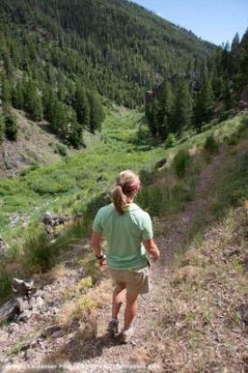
Murdoch Creek Trail:The out-and-back out Murdock Creek follows the bottom of a steep and narrow, avalanche-prone canyon. Constructed in 2010, this wheelchair accessible trail offers a consistent and gentle grade for more than a mile out the canyon. The route is an out-and-back. The first mile of the trail is open to all non-motorized traffic. After one mile the trail enters the Hemingway-Boulders Wilderness, where the trail becomes closed to bicycle traffic.
Directions: From Ketchum head north. The SNRA headquarters is about 8 or 9 miles north of town, on the right/east side of Hwy 75. Take the right into the SNRA entrance road and drive past the SNRA Headquarters to the first Y-junction. Take a right and continue .5 miles to the trailhead.
*For more detailed descriptions, topo maps, and information on the history, geology, and wildflowers of the Wood River Valley pick up a copy of Exploring Sun Valley online or find it at one of several local shops.
Photos
 |


