

STANDALONE TRAIL MAP
TRAIL INFORMATION

Details
| Status: | Partial |
| Difficulty: | Intermediate |
| Uses: | Mt Biking & Motorcycle & Road Biking & eBikes |
| Length: | 9.13 miles |
| Start: | 5,852' |
| End: | 6,878' |
| Min: | 5,850' |
| Max: | 6,883' |
| Gain: | 1,272' |
| Loss: | -246' |
| fly your trail in 3D | |
 |
Google Earth KML file
Download KML file above, open in Google Earth to see this trail in 3D! |
| don't get lost |
| GPX file (right click to download)
Download GPX file above, upload the track to your GPS or smartphone and you'll always know where you are!! |
Trailhead Forecast
Snowfall
New Snow last 12 hours: 0.34". New Snow last 24 hours: 0.8".Description / Access Information
Trail Creek Road:Trail Creek Road offers a convenient and beautiful road bike experience right outside of the town of Sun Valley. This route is an out and back experience going northeast on Trail Creek Road until the pavement turns to dirt. Trail Creek road continues as a dirt road the rest of the way up to Trail Creek Summit and beyond.
The road over the pass is closed each fall with the coming of the first significant snowfall events in the valley. The road is closed by Blaine County Road and Bridge. In 2017 the road closed on Nov. 7. In 2019 the date was Nov. 27. The road is reopened every springtime, when the snows and ice have melted away enough for crews to get to the avalanche debris and rock-slides. It takes a while to clear each spring - it is often open sometime in early to mid-May.
Starting in dowtown Ketchum, this ride passes the Sun Valley barn on its way out of town and then the historic Sun Valley lodge and the trailheads to the Sun Valley White Cloud hiking and mountain biking trails. Going east, riders pass the Sun Valley Club, the Sun Valley Gun Club and Trail Creek Cabin before further escaping into the Trail Creek drainage. Open views of this canyon immediately appear and the side drainages of Corral Creek offer additional beautiful vistas while the road slowly climbs close to 1000 feet.
There is also a separated Sun Valley bike path available starting just outside Ketchum and then following Trail Creek Road for a little more than a mile before terminating a little past the property of the Sun Valley Resort. This paved path passes the Hemingway Memorial and a foot trail that drops down to cross Trail Creek and gain the trails on Proctor Mt.
Photos
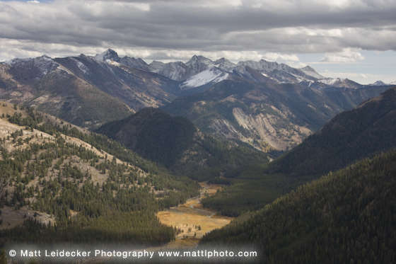 |
| Headwaters of Trail Creek |


