

STANDALONE TRAIL MAP
TRAIL INFORMATION

Cow Creek Short Cut Tr. #930
// track pieces: 202, // elevation pieces: 202
Details
| Status: | Open |
| Difficulty: | Intermediate |
| Uses: | Mt Biking & Hiking & Equestrian & Motorcycle & eBikes |
| Length: | 0.6 miles |
| Start: | 6,912' |
| End: | 6,793' |
| Min: | 6,748' |
| Max: | 6,915' |
| Gain: | 64' |
| Loss: | -183' |
| fly your trail in 3D | |
 |
Google Earth KML file
Download KML file above, open in Google Earth to see this trail in 3D! |
| don't get lost |
| GPX file (right click to download)
Download GPX file above, upload the track to your GPS or smartphone and you'll always know where you are!! |
Trail Info
REMARKS:
Many of the lower Greenhorn trails and dry. You will find some snow and muddy conditions where the trails move into trees and on some north facing aspects, especially as you go higher.
Wood River Trail Coalition reports that the WRTC's Greenhorn Improvements Project in collaboration with the USFS-KRD is going great! They have finished work on the new Greenhorn reroute and it is open. Be sure to check their home page for full details on the rest of phase 1 of the Greenhorn Improvement project.
Trailhead Forecast
Description / Access Information
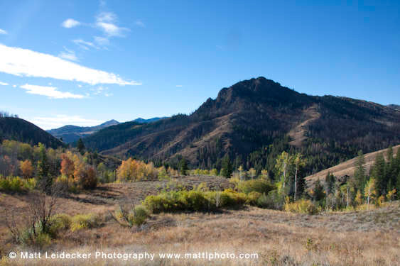
Cow Creek Shortcut Tr. #930: This trail provides a link between the east leg of the Cow Creek Trail No. 180 and the Cow Creek Connector Tr. No. 153. The trail contours through several small aspen groves tucked into a spring-fed basin. There are great views of the fire-scarred Mahoney Butte across the valley. This is also a great hike to appreciate and photograph the aspens turning yellow in the fall.Directions to the Greenhorn Trailhead: At the intersection of Highway 75 and Greenhorn Road (at the Greenhorn/East Fork traffic signal, which is about 5 miles south of Ketchum, and approx. 6 miles north of Hailey) go west to follow the Greenhorn Gulch Road for 3.7 miles to its end at the Greenhorn Trailhead.
*For more detailed descriptions, topo maps, and information on the history, geology, and wildflowers of the Wood River Valley pick up a copy of Exploring Sun Valley online or find it at one of several local shops.
Photos
 |
| Cow Creek Connector in fall |


