

STANDALONE TRAIL MAP
TRAIL INFORMATION

Details
| Status: | Open |
| Difficulty: | Intermediate |
| Uses: | Mt Biking & Hiking & Equestrian & eBikes |
| Length: | 7.3 miles |
| Start: | 5,496' |
| End: | 5,861' |
| Min: | 5,495' |
| Max: | 6,417' |
| Gain: | 1,390' |
| Loss: | -1,025' |
| fly your trail in 3D | |
 |
Google Earth KML file
Download KML file above, open in Google Earth to see this trail in 3D! |
| don't get lost |
| GPX file (right click to download)
Download GPX file above, upload the track to your GPS or smartphone and you'll always know where you are!! |
Trail Info
REMARKS:
Trails are clear and dry, and there are some great options for getting out on the Croy trails.
Trailhead Forecast
Description / Access Information
Two Dog Trail: This is a fun rolling trail that can be used as part of a longer loop around the perimeter of the more easterly area of the BLM Croy trail system. The trail can also be used as part of shorter loops utilizing Centerline, Punchline, and Wilson Gulch trails.
Two Dog was designed with intermediate skill and fitness-level mountain bikers in mind, but it is also popular with trail runners. The trail features berms (banked turns) and a very undulating character.
The trail can be accessed from the Croy Trailhead by utilizing the lower leg of the Bullion Connector Trail to gain the trail. The trail can also be accessed from its more western end - off of Bullion Gulch Road. From the Bullion Gulch side the trail climbs through several turns to a longer traversing climb to a saddle. The view to the east, from the high saddle on Two Dog, provides you with a nice view of the distant Pioneer Mountain range.
Directions: Please use the Croy Trailhead or the Bullion Gulch Road access if you are driving to access this trail. For the Croy Trailhead head west from Hailey for 3.5 miles on Bullion St./Croy Canyon Road. Look for the small green street sign marking "Trailhead Rd." on the right/north. Turn right onto the gravel road and proceed a short distance to the parking lot at the trailhead. To gain Two Dog Trail, proceed through the opening in the fence at the north end of the parking lot and bear right to get on the start of the Bullion Connector Trail. After a very short distance you will arrive at an intersection of trails, where Two Dog begins at your right. You can stay on the Bullion Connector, or climb on Two Dog. Both are fun climbs, or descents. Both are open to two-way traffic, so keep your eyes open and travel safely.
If you choose to use the Bullion Connector Trail please note that it leads up through the motocross track area found at the Croy Trailhead. It crosses the track in a couple of places, so use extra caution at these crossings. The Bullion Connector Trail leads up to a saddle where a number of trails come together. The Two Dog Trail heads up to the same saddle and intersection of trails. From the saddle Two Dog heads northeast. From the saddle you can also stay on the Bullion Connetor Trail or jump onto the one-way, mountain bike only, Punchline flow trail.
For the Bullion Gulch access to Two Dog Trail, go west from Hailey on Bullion Street/Croy Canyon Road for about 4.5 miles to Bullion Gulch Road on the right/north. (Note: If your reach the intersection with Rock Creek Road you have gone too far by a very short distance.) Heading up Bullion Gulch for 1.6 miles brings you to the west end of Two Dog Trail on the right/east. There is parking for a few vehicles here.
*For more detailed descriptions, topo maps, and information on the history, geology, and wildflowers of the Wood River Valley pick up a copy of Exploring Sun Valley online or find it at one of several local shops.
Photos
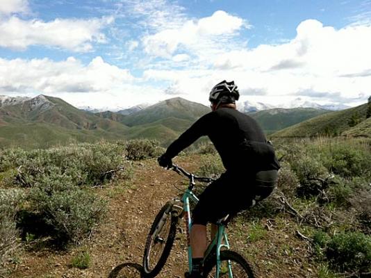 |
| Two Dog Saddle |
.jpg) |
| Two Dog in the fall |
Videos
 |
| Helmet cam of Two Dog |


