

STANDALONE TRAIL MAP
TRAIL INFORMATION

Details
| Status: | Partial |
| Difficulty: | Intermediate |
| Uses: | Mt Biking & Hiking & Equestrian & Motorcycle & eBikes |
| Length: | 4.47 miles |
| Start: | 7,138' |
| End: | 9,442' |
| Min: | 7,138' |
| Max: | 9,442' |
| Gain: | 2,431' |
| Loss: | -120' |
| fly your trail in 3D | |
 |
Google Earth KML file
Download KML file above, open in Google Earth to see this trail in 3D! |
| don't get lost |
| GPX file (right click to download)
Download GPX file above, upload the track to your GPS or smartphone and you'll always know where you are!! |
Trailhead Forecast
Description / Access Information
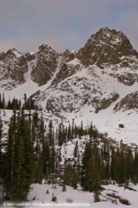
Boulder City Road: Old mining road hike to well preserved mining structures high in the Boulder Mountains.
While the actual hiking into Boulder Basin via the rocky mining road leaves a bit to be desired, the destination and historical setting is well worth the effort. The remnants of Boulder City host some of the best preserved mining structures in the Wood River Valley. Ringed by several north-facing alpine cirques, the area holds snow into early summer and was utilized in the 1940s by Sun Valley Ski School to extend their ski season. Modern ski mountaineers would do well to follow their example.
Don’t expect a pristine wilderness environment. The road opens access to motorized traffic and is utilized by jeeps and ATVs in the summer and snowmobiles in the winter. It is possible to drive up into the basin with high clearance four-wheel-drive, but the road is a commitment with few opportunities to turn around. For casual off-road drivers, it is not recommended to drive beyond “Boulder Creek #3.”
Directions: Drive north on Highway 75 to the Boulder Canyon road at the top of Phantom Hill (12.9 mi), turn right. Stay left at the first and right at the second Y-junction (1 mi). Park at the creek crossing, “Boulder Creek #1” or continue to the main trailhead “Boulder Creek #2” and park on a large open bench (.8 mile).
Photos
 |
| Boulder City |


